Friday, January 2, 2015

Desert Botanical Garden

Desert Botanical Garden lies about 10 kilometers (6 miles) southeast of Turpan City, Xinjiang Province. It is the largest botanical garden in China, built on a bottomland (low-lying area), where the average altitude is -80 meters (-262 feet). The garden is positioned in an extremely windy area, where one finds quicksand and an often unforgiving climate. It's location has earned it nicknames such as the 'Wind Storeroom' and 'Land of Fire', because this area is home to the most ferocious winds in all of China. Indeed, one might rightly call it the mother of all gale-force wind tunnels, since it regularly churns out gale-force winds reaching a level of 8 on the Beaufort-12 scale. On an average year, there is a gale-force wind of level 8 that lasts for a month, and in some years it lasts for up to two months.
The Desert Botanical Garden began as a sand-control station in 1972, and was converted into a botanical garden in 1976. As one of the 12 botanical gardens directly under the lead of Chinese Academy of Social Sciences, it is used for importing, domesticating, and expanding sand-fixation plants. It is filled with plants, flowers, and herbal medicines - highlighting a collection of commonly used herbal medicines from Uigur. The area is also used as an area to test sand-control methods as well as a tourist destination. The garden includes seven different parts, categorized according to uses and vegetation.
There are altogether more than 300 sandy-soil plants being preserved here, comprising 71 genera, with 247 species, of which 49 species are precious plants on the verge of extinction, including a species of the Chinese date, or jujube (which, unlike the palm-tree date of Middle Eastern deserts, is a deciduous shrub), the sand ilex, the white thorn, various liquorices, etc.
These 247 species of plants comprise roughly 80% of all desert plants found in sandy-soil areas throughout China. The Chinese Tamarisk Garden maintains 15 different tamarisk varieties, which account for 83% of all the tamarisk plants of China. When the tamarisk tree is in bloom, it fills the garden with red, and a sense of springtime invariably pervades the area. The Herbal Medicine Garden deserves special attention, as more than 50 herbal medicine plants from China's Xinjiang Uighur Autonomous Region, from Kazakhstan, and from Mongolia have been collected and replanted here, establishing the Herbal Medicine Garden as an important research center for herbal-medicine plants.
The desert arboretum is intersticed by a series of interconnecting roads and a network of irrigation pipes, and with various adjacent support facilities.  A corresponding scientific research facility with nearby housing blocks for the research facility's staff have also been constructed within the arboretum. With its focus on the re-introduction and preservation of rare desert plants, including a number of plants that are on the verge of extinction, the Desert Botanical Garden of Turpan ranks as one of the primary plant-preservation arboretums for sandy-soil plants in the world, providing not only economic benefits, but also zoological benefits to China as well as to the entire world.
The Desert Botanical Garden of Turpan boasts an observation tower whose telescope offers spectacular views of the Bogda Peak of the Tianshan Mountains, the Flame Mountain Range, the Grape Valley, and Ayding Lake. It is THE place to go to take in the expanse of the topography surrounding the city of Turpan. Together with the Ancient City of Jiaohe and Karez System, this botanical garden has become one of the most popular tourist destinations in Turpan. From the watchtower inside it, one has an excellent view of the Flaming Mountains, the Grape Valley, and the Aydingkol Lake, all of which will make a visit to Turpan even more enjoyable.
For more information, please visit http://top-chinatour.com

Thursday, January 1, 2015

Ancient City of Gaochang

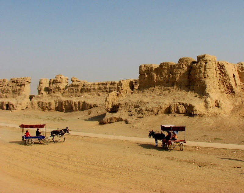
The ancient town of Gaochang was once the capital city of the Gaochang (Kocho, Kharakhoja or "King City") Uigur Kingdom. Lying at the Mutougou River Delta at the foot of Flaming Mountain, 45 km east of Turpan City of the Xinjiang Uigur Autonomous Region, Gaochang served as an important commercial and cultural center on the ancient Silk Road and played an important role in the history of communication between ancient China and the West. The once thriving capital city was gradually deserted over a period of more than 2,000 years, but the site of the ancient town is still visible and the city wall still stands in the basin not far from Flaming Mountain. Withstanding the test of time and weather, the ancient city of Gaochang, and the ancient city of Jiaohe, are the best-preserved ruins of the ancient cities in China. These two cities were added to the World Heritage List on June 22, 2014.
The city was initially built as a garrison town in the first century B.C., called Gaochang Wall, and later renamed Kharakhoja, Kocho or King City. It was a key point along the Silk Road. During the successive dynasties, it was ruled as Gaochang Prefecture, Gaochang Kingdom and West Prefecture. By the 14th century, the city was damaged and abandoned due to warfare between Mongolian aristocrats and Uigurs. After 2,000 years, the weather-beaten ancient city still displays its past greatness and glory even though the walls are incomplete the magnificent outline remains.
The present remains of Gaochang City that was built in the Tang Dynasty (618-907) and rebuilt and enlarged in the Huihu period cover an area of over 2 million square meters. Most city wall remains were made of tampered earth. Taking a shape of an irregular square, the whole city was divided into three sections, namely the outer city, the inner city and the palace.
The outer city had a wall base of 12 meters thick, 11.5 meters high, with a perimeter of 5.4 kilometers. The outer side of the city wall was well preserved, with horse face figures protruding outward. Three gates were open in the south wall, while the other three walls each had 2 gates, of which the north gate open in the west wall was the best preserved one. Built outside the city gates were a number of small protective towns, equipped with defense facilities.
The inner city was built in the center of the outer city, with well-preserved west and south walls. Built earlier than the outer city, the inner city had a rectangular shape. The palace, built in the uttermost north of the outer city, took the north wall of the outer city as its north wall and the north wall of the inner city as its south wall.
The Palace City is located in the north of the inner city, sharing its southern wall with the inner city and northern wall with the outer city. It is a rectangle with a perimeter of 700 meters (2,296 feet). Within the city, many large  cornerstones remains are still visible, with an average height of 3.5 meters (11.5 feet) to 4 meters (13 feet). These cornerstones are relics of a 4-storied palace. An irregular adobe square standing in a high earthen platform is called "Khan's Castle", which was the imperial residence.
During late 19thcentury to early 20thcentury, grave robbers from Russia, Germany, Britain, and Japan plundered cultural relics at the Ancient Gaochang City. Renowned Chinese scholar Huang Wenbi twice surveyed the city in 1928 and 1930. After the founding of new China, cultural relic administrative bureau was set up to carry out further researches at the site and unearthed a number of valuable relics.
For more information, please visit http://top-chinatour.com

Wednesday, December 31, 2014

Karez System----- 'the underground Great Wall'

Karez is a unique irrigation system mainly distributed in Turpan district in Xinjiang Uighur Autonomous Region. Karez systems are the crystallization of ancient people's diligence and intelligence. At its peak, this irrigation system exceeded 5,000 km (3,106 miles) and was also referred to as 'the underground Great Wall'. It is among the three ancient major irrigation projects with the other two being Ling Canal and Dujiangyan Irrigation Project. The history of it can be traced back over more than 2,000 years ago.
Karez systems are the life source of Turpan. In a sense, without them, there would be no Turpan culture. According to records, the history of the karez in Xinjiang dates back to 103B.C. Karezes have been found in Iran, the Sahara, etc., but the ones in Turpan are the most complete. Currently there are still over 400 systems.
Karez are very delicate irrigation systems made up of vertical wells, underground canals, above-ground canals and small reservoirs. Generally, a karez is 3 km (1.9 miles) with the longest being 20 to 30 km (12-19 miles) with several dozen vertical wells. Sometimes the number of vertical wells exceeds 300. Until today, the shortest karez found is only 30 meters (98 feet) long. The vertical wells are for ventilation, digging and maintenance of the karez. The bottoms of all the vertical wells are connected so that water can pass through. The underground canal is about 2 meters (6.5 feet) high and covered with earth to resist the heat. The surface canals, connected to the underground ones, are not more than 1 meter (3.2 feet) wide with trees planted on both sides to prevent evaporation.

Melting snow from the Tianshan Mountain is the water source of the karez. Water is collected by vertical wells and conducted by the underground canals to the oasis, where the water is held in the ground canals for irrigation. The vertical wells near the water source may be 100 meters (328 feet) deep while further downstream they are less than 10 meters (32.8 feet) deep.
There are more than 1400 Karez wells in Turfan. They also play the roles of natural air conditioner for the locals because they can sit in one while chatting or doing some chores. When exhausted during the scorching weather, sit in a karez, pick some grapes as they hang over the vertical wells and savour their taste, you will be thoroughly refreshed! Karez System really makes you understand how the people of Xinjiang have brilliantly managed the water supply in this desertic land.
For more information, please visit http://top-chinatour.com

Tuesday, December 30, 2014

Nalati Grassland-----‘The Sky Grassland’

Nalati Grassland, one of the world’s four largest grasslands, it is locates to the east of Nalati Town of Xinyuan County. It is the highest prairie in China with lush grassland and surrounding mountain and a home of meadow vegetation. Owing to its high altitude and steep terrain, it is also called ‘The Sky Grassland’. It has been a famous pasture since ancient times.
A beautiful story is associated with the grassland. During the last years of the Southern Song Dynasty (1127-1279), Genghis Khan made a west expedition to Ili in midsummer. However, it was very cold in the mountains, further exhausting the already hungry soldiers. To their surprise, after crossing a mountain, they saw a boundless stretch of grassland. Dainty flowers were in full bloom and clear streams murmured over the lush green grass. It looked like a marvelous wonderland, so soldiers shouted happily ‘Nalati, Natati’.
Nalati scenic area covers 400 sq km of the country's second largest grassland. The grassland has quiet streams, fresh air and abundant vegetation. It is home to a 10th of China's Kazakh community, and its rolling hills are dotted with their camps. The landscape is carpeted with wild flowers, upon which wander herds of goats, sheep and cows. A must-do in Nalati is staying a night in a Kazakh camp.
From June to September, the vast expanse of lush grassland is dotted with colorful wild flowers. The surrounding snow mountains, white clouds, blue sky make this grassland more charming. Thus, this period is the best time to visit this wonderland. Many activities are held in this ‘Cradle of Kazaks’. Kazakhs who are good at dancing and singing live here still retains the rich simplicity of folk customs and rich grassland culture. Unique natural landscape, history, culture and rich ethnic customs make Nalati Grassland Scenic an unique place to go.
For more information, please visit http://top-chinatour.com

Monday, December 29, 2014

Hetian Museum

Built in 1995, Hetian Museum has an area of 3400 square meters. It boasts over 9000 pieces of cultural relics; most of which were discovered by archaeologists after 1949 and a small number were donated by the locals. Hetian museum opened in 2005, it is located on West Beijing Road in Hetian, Xinjiang. The main halls are situated on two floors and display the historical relics and items reflecting the present local folk customs respectively.
Hetian, being the largest oasis on the south of Taklamakan Desert, was the territory of many ancient regimes such as the Kingdom of Khotan. Many ancient cities and tomb sites have been discovered in this area and these include the Shanpula tombs, the Niya and Mazhatage Sites and the site of the ancient Yuansha city. Many relics and models of these tomb sites are exhibited in this museum and give people a chance to get close to this place and learn about the culture of western regions in ancient China.
The Hotan Cultural Museum exposition is divided into two parts. On the ground floor, there is a collection of monuments of ancient civilizations, once existed in the territory of Eastern Turkestan. There you can see ceramic ware, jewelry, and household items. In addition, the museum features fragments of ancient tombs and sarcophagi, which are several thousand years old. One of the most valuable exhibits is considered two mummies of a girl and a man who are more than 1500 years old.
The museum’s first floor holds a collection, unofficially called the Uighur one. It opens an amazing and colorful world of Uighur culture to the museum visitors. There you can see ancient clothing and jewelry created by the hands of the ancient masters, as well as various Uighur artware. On the second floor, Hetian Uygur folk culture is illustrated by exhibits of local jade and carpets, the local silk, Uygur dresses, folk art and handicrafts, as well as Uygur medicine and food culture. Among the prized relics in this hall are a carpet into which a map of China is woven and a large copper pot.
The collections in the Hetian Museum provide a vivid picture of the splendid culture of ancient Hetian area in the fields of manual textile technology, art pottery, painting art and the Buddhist culture.
For more information, please visit http://top-chinatour.com

Sunday, December 28, 2014

Sayram Lake-----the Largest Alpine Lake in Xinjiang

Sayam is enchased in the hinterland of TianshanMountainIt is 93.6 kilometers southwest of the Bole City, on the north side of the Urumchi-Yining RoadSayram in Kazak means blessing while in Mongolia means lake on the mountain ridge”.The lake is the largest alpine lake in Xinjiang and lies at the highest altitudewith a height of 2,072 meters above sea levelIt is about 29.5 kilometers long from east to west and about 23.4 kilometers wide from north to south, occupying an area of 458 square kilometersThe lakeabout 90 meters deep at the greatest depthholds 21 billion cubic meters of water.
Thc Sayram Lake is on the northern Silk Roadand present Urumqi-Ili highway runs along the Southern bankBeside the lake and on the mid-lake islandhistoric spots like the Longwang Temple (Dragon King Temple)the Hai Templeand other constructions once were buntbut now all have unfortunately disappeared.
There is a touching love story about Sayram Lake. It is said that it was composed of the tears of a couple of Kazak young lovers. A beautiful girl and a young man were deeply in love. One day, a cruel devil was captivated by the girl's beauty. He captured the girl and confined her to his residence. The girl took a chance to escape, but the devil found out very soon and went after the girl. She was forced to jump into an abyss. Later, her boyfriend heard of this and he was so sad that he jumped into the abyss to be reunited with his lover. Their painful tears flooded into the abyss and formed Sayram Lake.
The scenery is quite varied in four seasons. In the springsummer and autumn the sapphire water of the lake seems to meet the sky in the distanceThe pasture is a charming scene of flourishing treeswaving grassand wildflowers that are reflected in the clear water of the lakeIn the winter, snow falls and the water of the lake turns to iceOnly a Small portion of the lake can be seen in the vast whiteness of the ice and snow.
In July and August, local 'Chahra' Mongolian and Kazakh herdsmen converge onto the pasture to hold a grand festival, known as the Nadam Festival. Mongolian people celebrate the "Nadam Fair" for six days beside the lake. Nadam means recreation or games in Mongolian. During the Nadam Fair, competitions are held in horse-racing, wrestling and archery, which are considered the three basic skills of men. Mongolian, Kazak, Han Chinese and people of other ethnic groups in Xinjiang participate in the festival. Mongolian herders from nearby regions attend the fair and dress in traditional ethnic costumes. In addition to the competitions, there is singing, dancing and the age-old competition of "girl-chasing". The Kazak horse back games of "Buz Kashi" and "Girl-Chasing" promise a rich cultural experience of the well-preserved traditions unique to this remarkable region. The fair is great fun for tourists and very entertaining. It is rewarded with lasting impressions of a cultural continuum that has its roots in the beginning of Central Asian history. During this time, Sayram Lake is blessed with a double portion of good fortune in water and pasture.
For more information, please visit http://top-chinatour.com

Saturday, December 27, 2014

Lop Nur

Lop Nur which means a vast lake is a former salt lake in China, now largely dried-up. Located in the northeast of Ruoqiang County, Lop Nur is about 780 meters (2,560 feet) above sea level and covers an area of about 3,000 square kilometers (1,160 square miles). Once it was the second largest inland lake in China and an important station on the Silk Road.
The lake system into which the Tarim River and Shule River empty is the last remnant of the historical post-glacial Tarim Lake, which once covered more than 10,000 km2 (3,900 sq mi) in the Tarim Basin. Lop Nur is hydrologically endorheic— it is landbound and there is no outlet. The lake measured 3,100 km2 (1,200 sq mi) in 1928, but has dried up due to construction of dams which blocked the flow of water feeding into the lake system, and only small seasonal lakes and marshes may form. The dried-up Lop Nur Basin is covered with a salt crust ranging from 30 cm to 1 m in thickness.
In the broad sense, Lop Nur refers to the Lop Nur desert area which spans Xinjiang and Gansu Provinces. The Spectacle of the Gobi Desert and some historical sites are also scattered in this area, including the dragon-shaped Yadan Landscape, Rose-Willow Valley, the Peacock River, a dead forest of diversiform-leaved poplar (populus diversifolia), a Han Dynasty (206BC-220AD) beacon tower, the Sun Tombs, the Milan Farm and the Loulan Ancient City.
Situated on the northern bank of the Peacock River, the Sun Tombs have a history of about 3,800 years. Around each tomb are seven circles formed by wooden spikes pointing toward the sun. The tombs are full of mystery. No one knows who were buried there and where they were from.
The Loulan Ancient City is one of the great mysteries in Chinese history. It existed for only 400 years or so, disappearing in the 4th century. Its disappearance is still a riddle. The 'Loulan Beauty' (a female mummy), tombs and colorful coffins attract explorers, historians and visitors to the area.
Xioahe Tomb is also famous to people. The Xiaohe Tomb complex is located to the west of Lop Nur. This bronze-age burial site is an oblong sand dune, from which more than thirty well preserved mummies have been excavated. A total of 167 tombs have been dug up since the end of 2002 and excavations have revealed hundreds of smaller tombs built in layers, as well as other precious artifacts. In 2006, a valuable archeological finding was uncovered: a boat-shaped coffin wrapped in ox hide, containing the mummified body of a young woman. She was called “Princess Xiaohe” because she was found at Xiaohe. The most amazing thing is that her hair was preserved very well and people can see the smile on her beautiful face.
Lop Nur is a paradise for visitors who love adventure. There are some suggestions for the adventurers. First, go there in the middle of April and October to avoid strong sandstorms. Second bring enough food, water and necessary medicines. Last but not leastdo not forget satellite phones, GPS or other communications tools
For more information, please visit http://top-chinatour.com